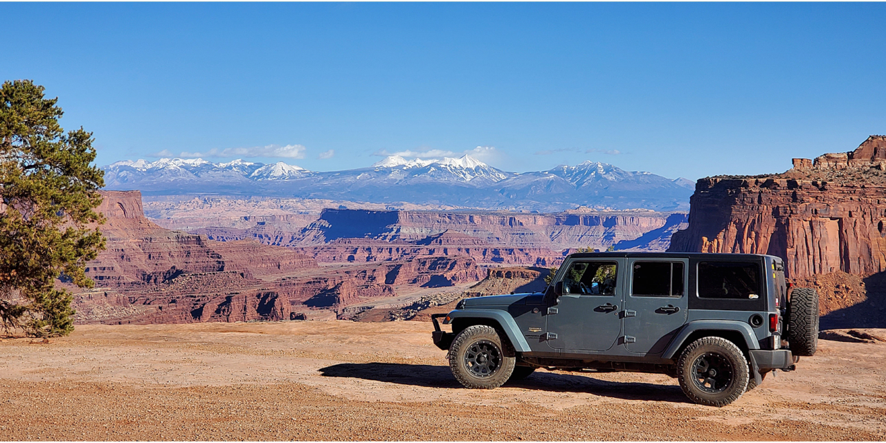
Moab, Utah, is mainly known for its National Parks and Jeep trails, and we spent much of our time doing both. One of our favorite trails was Shafer Trail, which was recommended by our friends Alli and Sean from Here Then Gone. If you go, prepare for AMAZING views (and possibly a heart attack).
Looking for something specific? 👇
Directions to Potash Road
We were north of Moab, took US 191 south to Potash Road (aka SR 279), and headed west. The road follows the Colorado River for several miles, passing through a canyon that is a rock-climbers paradise. We saw a bunch of people rock climbing. You can also find petroglyphs, arches, and several trailheads on this road.
Attractions on Potash Road
Once the pavement ended, we wound our way up from the canyon floor, through red rock hills, and to the famous “Balanced Rock.” A few days later, we happened to watch the movie 127 Hours, and we swear you see this rock when he's having flashbacks after he was already stuck. Next, we came to some strange blue-colored ponds called the Potash Evaporation Ponds. These are evaporation ponds for potassium chloride, or potash, commonly used as fertilizer.

After we passed the ponds, we came to ‘Thelma and Louise Point', which was made famous by the 90s movie. This exact spot is where the main characters launched their car off a cliff, running from police in the film. This spot offers an insane view of the river several hundred feet below.

The next stretch of the trail offered excellent views of the river and canyon, and at one point, we squeezed between a cliff and the canyon wall—definitely a no-passing zone.

At this point, our trail turned away from the river and started into Shafer Canyon. It was several more miles on Potash Road, surrounded by tall canyon walls and rock formations before we officially entered Canyonlands National Park and turned onto Shafer Trail.

Attractions on Shafer Trail
After about 2 miles of relatively easy driving, we noticed the incline getting steeper and steeper until we came to the first switchback (remember the heart attack?). That began roughly a dozen switchbacks and sharp turns, some only wide enough for one vehicle.

Luckily, it's only 1,500 feet to the top! If heights aren't your thing, you might want to ride shotgun and close your eyes for this section. We stopped a few times along the way for some incredible pictures and only had one argument and a freak-out moment. Once we reached the top, we were rewarded with a HUGE view of Shafer Canyon.

After the adrenaline wore off, we headed to the Island in the Sky visitor center of Canyonlands National Park to round out the day. We didn't visit Canyonlands National Park any more and sadly didn't get a chance to return on this trip.

Recommendations
It was about a 20-mile trail and took us several hours, mainly because we had to stop for many pictures. It's not a difficult trail, especially compared to many in the area, and can be done with most high-clearance vehicles. We never used our four-wheel drive on this trail.
In my opinion, the switchbacks are the challenge and will more than likely give even the calmest person anxiety because of the extreme height combined with the narrow road.
Ultimately, the gorgeous views from start to finish made all the heart attacks, arguments, and freak-out moments worth it. It's a trail I would do again when we go back to Moab!
Podcast
We talked about Shafer Trail and other fun trails in the first episode of our podcast. You can find the podcast on the app you use to listen to your podcasts. Find more links and information on the show notes page for that episode.
Hey adventurers! 🚐
Did this episode spark some wanderlust, or did it remind you of one of your own off-the-beaten-path stories? If you felt that campfire friendship while listening, we would be super grateful if you’d take a moment to pop over to Apple Podcasts. Please leave us a rating, maybe say hi in the review section, and don’t forget to subscribe. It’s like giving a friendly nod to a fellow RVer on the open road.
Do you have a hidden gem of a location you think we should explore next? Or maybe a practical tip for full-time RV living? Leave us a message—this journey is all the richer when shared with the community.
🏞️ Safe travels, and see you down the road!
SUBSCRIBE: APPLE PODCASTS | PODBEAN | SPOTIFY | IHEART RADIO | PANDORA | TUNEIN | Plus, almost all podcasting apps. Let us know if you can't find us on your app.

